|
What is NTN ?
NTN stands for Non-Terrestrial Networks, a concept in telecommunications that refers to communication networks that use non-terrestrial assets, such as satellites, high-altitude platforms, or drones, to provide connectivity. NTNs are part of the broader effort to extend network coverage beyond the limitations of terrestrial infrastructure.
NTNs are revolutionizing the way we think about connectivity by extending communication beyond traditional terrestrial infrastructure. Leveraging assets like satellites, high-altitude platforms, and unmanned aerial vehicles, NTNs bridge the digital divide by delivering reliable and high-speed connectivity to even the most remote and underserved regions of the world. As part of the evolving 5G ecosystem, NTNs integrate seamlessly with terrestrial networks to provide enhanced coverage, low-latency
communication, and support for the growing demands of IoT and machine-to-machine (M2M) applications. With their ability to address challenges like disaster recovery, maritime and aviation connectivity, and secure communications in critical scenarios, NTNs are poised to play a transformative role in the future of global telecommunications. However, the journey to fully realize their potential involves overcoming challenges like latency, integration, and cost, making NTNs a dynamic and rapidly advancing field of
technology.
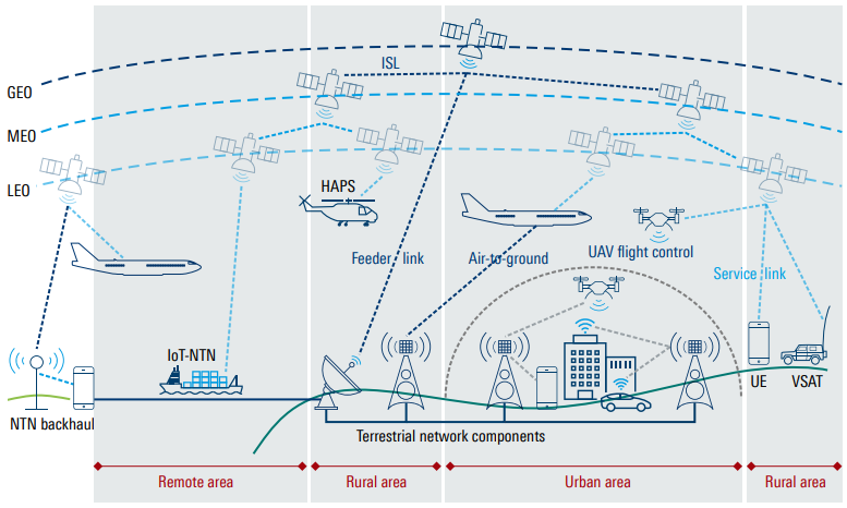
Image Source : Non-terrestrial networks (NTN) - R&S
Followings are brief descriptions on the components and links :
- Satellites (GEO, MEO, LEO):
- GEO (Geostationary Earth Orbit): Provides broad coverage but higher latency due to its altitude (~36,000 km).
- MEO (Medium Earth Orbit): Balances coverage and latency.
- LEO (Low Earth Orbit): Offers low-latency communication and is used for IoT and broadband services.
- High-Altitude Platforms (HAPS):
- Positioned in the stratosphere, these platforms (e.g., balloons or drones) support feeder and service links for connecting areas without terrestrial infrastructure.
- UAVs (Unmanned Aerial Vehicles):
- Used for flight control and as relay nodes, particularly in rural and urban environments.
- Links
- ISL (Inter-Satellite Link): Connects satellites within or across orbits, enabling data transfer between satellites without constant reliance on ground stations. Key for global coverage, efficient data routing, and low-latency delivery.
- Feeder Link: Connects ground stations to satellites or HAPS, acting as the gateway for NTN systems. Ensures high-capacity data transfer between the space segment and terrestrial networks.
- Air-to-Ground Link: Connects aircraft to ground stations or terrestrial networks, providing broadband services to flights. Critical for in-flight connectivity, even in areas without terrestrial coverage.
- Service Link: Connects satellites or HAPS directly to end-user devices (e.g., phones, sensors, VSATs). Enables last-mile connectivity, vital for remote, rural, or disaster-hit regions.
- UAV Flight Control Link: Manages communication with UAVs for safe operation and navigation. Supports real-time control and data exchange, especially for surveillance, logistics, or communication relay.
- NTN Use Cases:
- Direct to UE : Ordinary portable devices (e.g, smartphone)
- IoT-NTN: Connects IoT devices in remote areas, such as maritime vessels.
- Air-to-Ground: Provides connectivity for airplanes during flights.
- VSAT (Very Small Aperture Terminal): Used for rural connectivity or mobile stations (e.g., trucks).
- Terrestrial Network Integration:
- NTNs complement terrestrial networks by providing backhaul and service links to fill coverage gaps in remote or underserved areas.
- Geographical Distribution:
- Remote Area: NTN backhaul and IoT-NTN dominate.
- Rural Area: Feeder links and HAPS support connectivity.
- Urban Area: Dense terrestrial networks, supplemented by NTNs for UAVs and air-to-ground links.
3GPP Reference
Other References
YouTube
|
|